Tongariro Alpine Crossing Trip Report
I woke up groggy. I had been on the road later than I anticipated the previous night. There were periods during the drive where the rain was pouring, which made for an exhausting drive. Despite my fatigue, I was anxious to get started with the Tongariro Alpine Crossing. It is the most popular day-hike in New Zealand, but it is also particularly dependant on good weather. Just my luck, the weather was supposed to be perfect.
We spent the night at Tongariro Adventures, an amazing bed and breakfast I found on Airbnb run by Barb and her husband. Besides being an awesome place to spend the night, they also provided an incredibly hearty breakfast and a car spotting service for the Tongariro Alpine Crossing. We were quite lucky since we found out that the previous guests were unfortunate and were unable to start the hike due to bad weather. The host’s hospitality continued all the way to the trailhead where she offered to take our picture.
Tongariro is probably best known for being the setting of Mount Doom in Lord of the Rings. The crossing is a day hike, but it is also part of the Tongariro Northern Circuit; one of New Zealand’s Great Walks. Unlike Routeburn or Kepler, however, it is the most prominent feature in a relatively flat part of the country.
The Crossing is a long day hike, so we said our farewells to Barb and hit the trail!
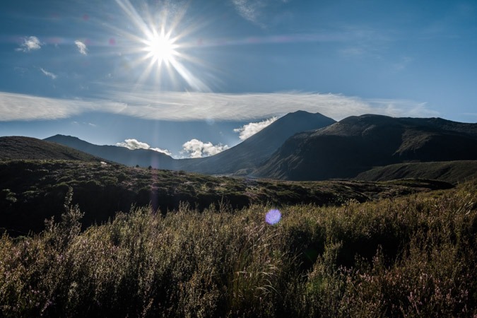
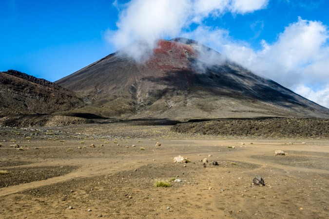
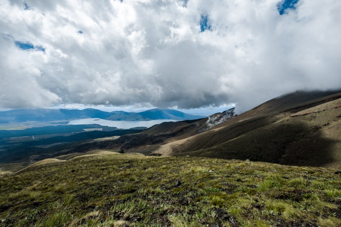
Kilometers 0-6 of the Tongariro Alpine Crossing
The first few kilometers are a very steady, slow incline. The scenery is very desolate since the trail winds through young volcanic deposits. The early part of the trail is right next to a small river. It offers a little bit of variety next to the dark volcanic soil.
It was immediately obvious how busy the trail would be. There were so many people walking on the path, it was rather frustrating getting stuck behind people wearing skirts. But we were in no rush; just hoping to enjoy our last major outdoor activity in New Zealand.
The sky had been clear, but there was a bit of cloud hanging just on top of the Crossing. As we started walking, however, the clouds began to clear. All of a sudden we had a perfect view right on Mount Doom (also known as Ngauruhoe ). Standing in the midst of this iconic landmark made me feel like I was on some epic quest – with a thousand of my closest friends!
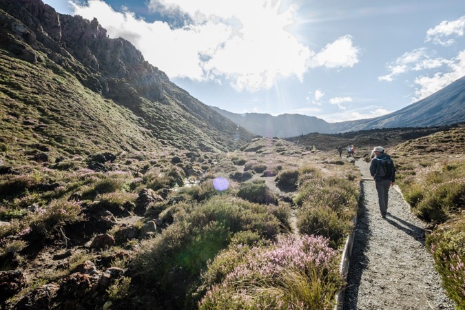
Kilometers 6-8 of the Tongariro Alpine Crossing
After winding through a valley for sometime, it was time to start climbing. It is said that the Tongariro Alpine Crossing is the toughest hike in New Zealand. I am not sure if that is true, but the initial climb is relentless.
In about 2 kilometers, you climb 500 meters. On top of being a lot of vertical gain over a short amount of time, there are also a ton of people on the trail, all travelling at their own pace. Eventually, we got to the top of the first part of the climb. There was still a hill to overcome, but suddenly there were sweeping views that stretched fat to the West.
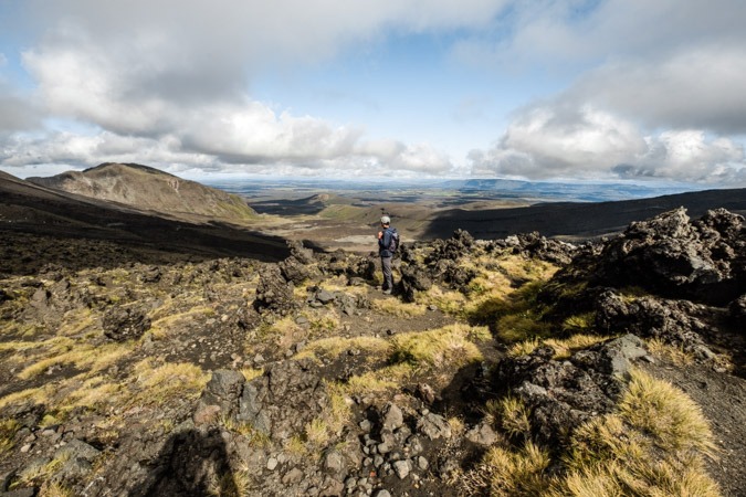
Unlike the trails in the Southern Alps, which traverse through mountainous country, Tongariro is a stand-alone mountain. Looking over the edge of the trail, there were no mountains obstructing the view – it was clear to the coast.
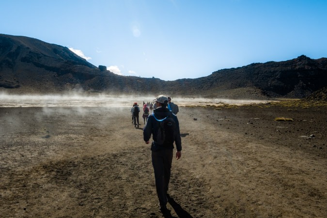
The trail at this point continued through a flat section in between two volcanic cones. The earth was steaming. Watching the line of people pass through the mist, it felt like I was watching a pilgrimage of sorts.
As we were walking through the mist, we saw someone take out a drone and start flying it. Tongariro is a no drone zone. Maybe this makes us buzz kills, but we told them there were no drones allowed on the trail, and they put it away.
After passing through the steaming strip of earth, the trail makes one final climb. The earth was looser there than in previous parts of the trail, so it took a bit more attention to footing. After about 10 minutes we were at the top.
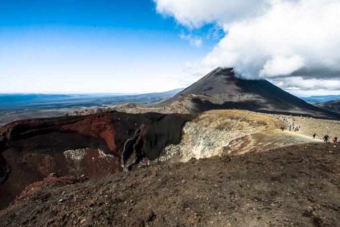
Lunch Break
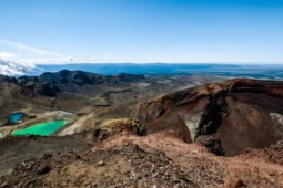
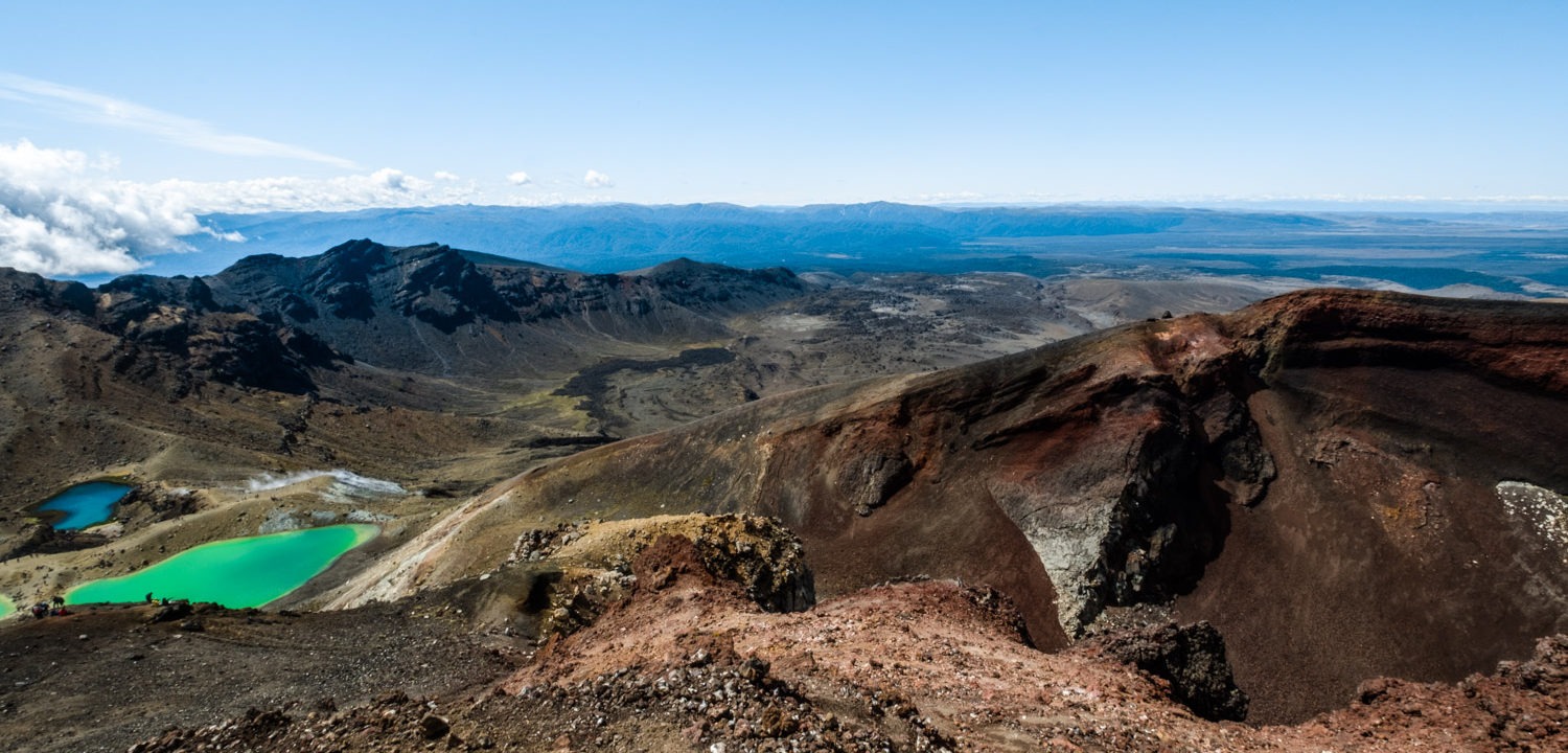
The views from the top were unreal. You could see Tongariro, Ruapeho, and Ngauruhoe. Beyond that, just rolling hills as far as the eye can see. We picked a seat on the edge of the trail overlooking a volcanic pit that was bright red.
We had packed sandwiches for the trip, so it was enjoyable just sitting up there taking in the view. I noticed a buzzing sound behind me. Another person was flying a drone. This time I went up to him and told him this was a no drone zone. He was a bit more combative than the first people, but he also put the drone away.
We finished up eating, and decided to continue our trek.
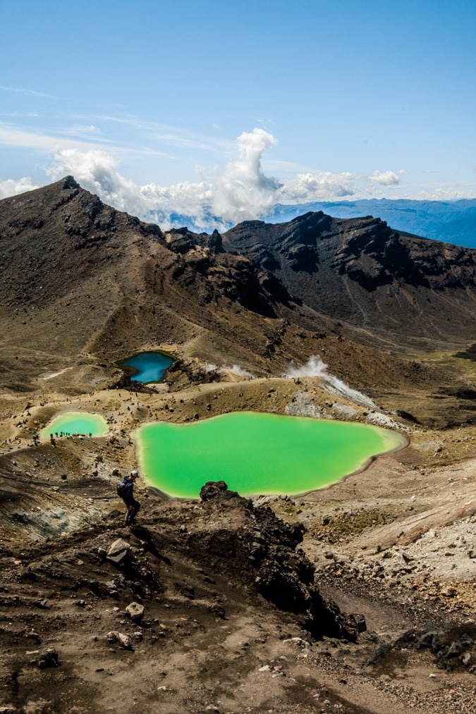
Kilometers 8-11 of the Tongariro Alpine Crossing
Upon leaving our lunch spot, the trail gets even looser very quickly. It felt like walking on sand. But, only a few meters from where we ate our lunch, we were treated to the greatest view of the entire walk.
This is really what people come to Tongariro to see, and I don’t blame them. The beauty is other-worldly and the colors are hues not frequently found in nature. Despite the beauty, it was very difficult to take a good photo here because of all the people.
We travelled down the side of the hill and decided to just sit by one of the pools for a bit. It was relaxing to just sit in such an amazing place and take in the bustle all around. The smell of sulfur was strong and huge patches of smoke were rising from beneath the ground. After fifteen minutes, we decided to continue our trip.
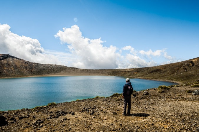
After passing by all of the pools, the trail makes one last climb up to a larger lake. It was quite a large lake. I was surprised to see some birds swimming in it. The path winds around the lake and then down the other side of the mountain. From the top, before making the pass to the other side, we took one last look at the beauty behind us, and began our descent.
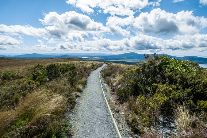
Kilometers 11-14 of the Tongariro Alpine Crossing
The rest of the trail is all downhill. At the top, it starts out through a grassy section of the side of the mountain. The views are nice, but the trail gets very narrow in some sections and it is difficult to pass people.
This part of the trek was surprisingly pleasant. The weather was really nice, the scenery was really pretty and Dennis and I were in good spirits as we were chatting. At a certain point, we passed another group of people with a drone. I felt a little fatigued playing the bad-guy for a third time, so we didn’t say anything as we passed by.
About a third of the way down the mountain, the trail passes by a hut that is no longer in commission. That’s because in 2012, the volcano erupted, spewing rocks down the side. One of those rocks plummeted right through the roof of the Ketatahi hut, into a bunk. Fortunately, no one was in the bunk at the time, but the DOC wouldn’t take the risk again and closed the hut permanently. It is really a shame since the hut is in a beautiful location. I hoped for a chance to see the hole the rock left in the bed as we passed by, but apparently the hut is completely closed off to the public.
There is still evidence of volcanic activity on the sides of the mountain, where large clouds of smoke were billowing.
Kilometers 14-19.4 of the Tongariro Alpine Crossing
The rest of the hike is just a continuation down the side of the mountain. Eventually, after descending enough, the trail enters tree-cover. As you continue down, the forest gets thicker and the trail gets muddier. We passed signs that warned about lahar dangers, which could prove deadly if the circumstances appeared.
About 7 hours after we started, we arrived in the parking lot. The trip was not over for us yet, though. Due to our relatively late start, we had to leave our car about a kilometer from the trailhead. We walked down the dusty road and eventually to the main road. Finally, we arrived back at our car.
We changed shoes, and began our drive to Rotorua.