Weeks of Wanderlust - Travel Blog
Home
Blog
About Me
Weeks of Wanderlust - Travel Blog
  • Home
  • Blog
  • About Me
Browsing Category
Uncategorized

Big Island Day 3

January 16, 2018 by Elsbeth 2 Comments

Our last day on the big island began with with alarm blaring at 5:45 AM. Very early start for vacation, but we were on a mission to catch the sunrise from Waipio Valley – Valley of the Kings! Luckily, the Airbnb was only a 5 minute drive from the overlook. We parked our car and headed down to the valley in the dark.

We arrived at the beach just as dawn was breaking. The view was breathtaking – pink hues filled the sky as giant waves crashed on the black beach. You couldn’t help but ask if you had arrived on the set of Lost. Despite being one of the islands main attractions, we were alone on the beach save for a couple of surfers. We spent about 45 minutes taking in the sunrise and enjoying the solitude before heading back up.

The walk back up was tough – climbing 1000 feet over less than a mile. From the top, we stopped at the overlook which we had skipped in the dark. In the distance you could see a mountain peeking over the cloud tops. It was Maui! I had no idea you could see Maui from the Big Island, but there it was! After a few moments, we headed back to the hostel to pack up and head to a well-deserved breakfast!

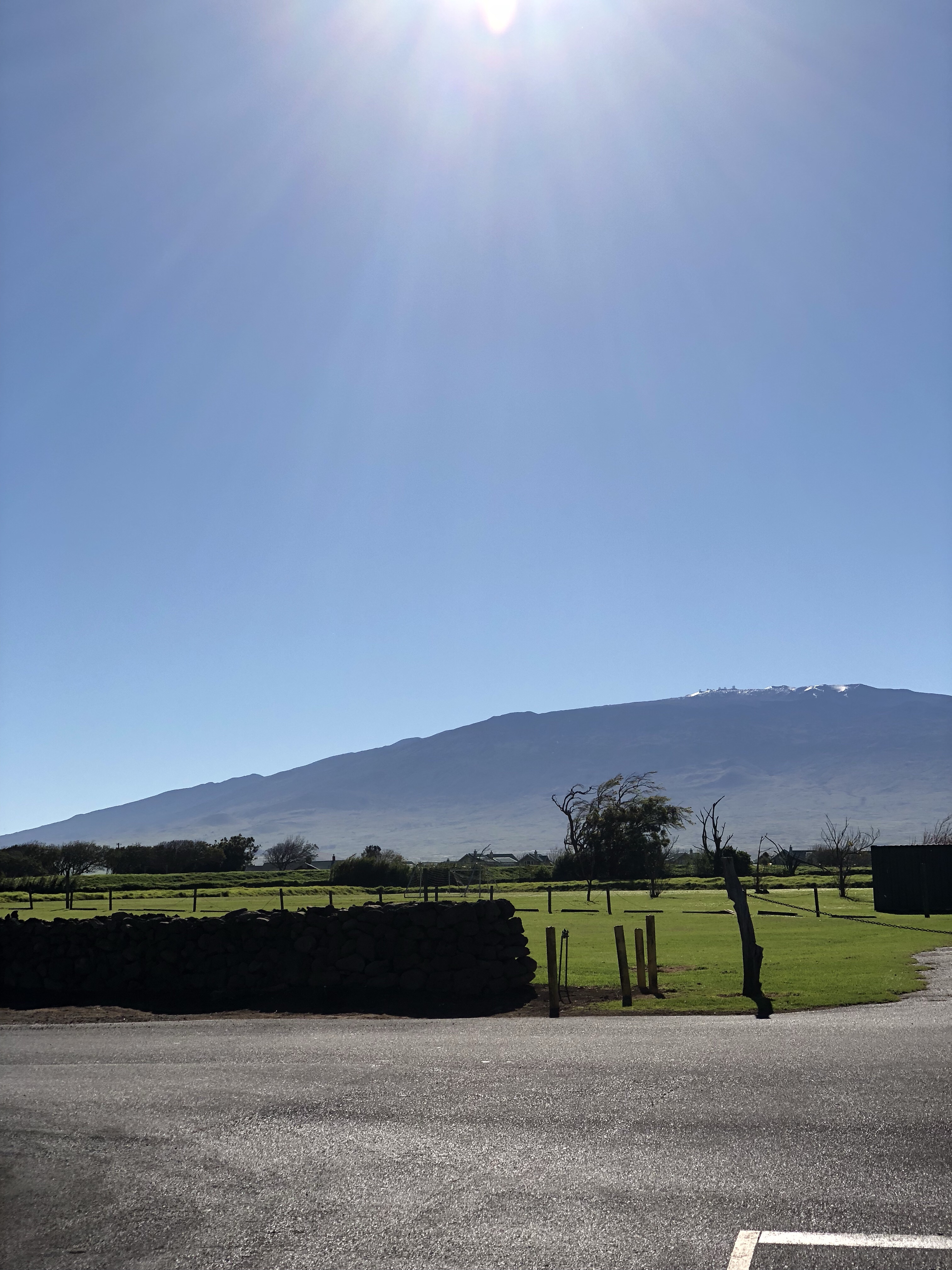
We made a pit stop in Waimea for a simple meal of eggs, sausage and toast. Nothing fancy, but it hit the spot! We continued driving back to the Kona side. Leaving the restaurant parking lot, we were treated to a view of Mauna Kea, complete with snow on the top. I can now say I have seen snow in Hawaii – achievement unlocked!

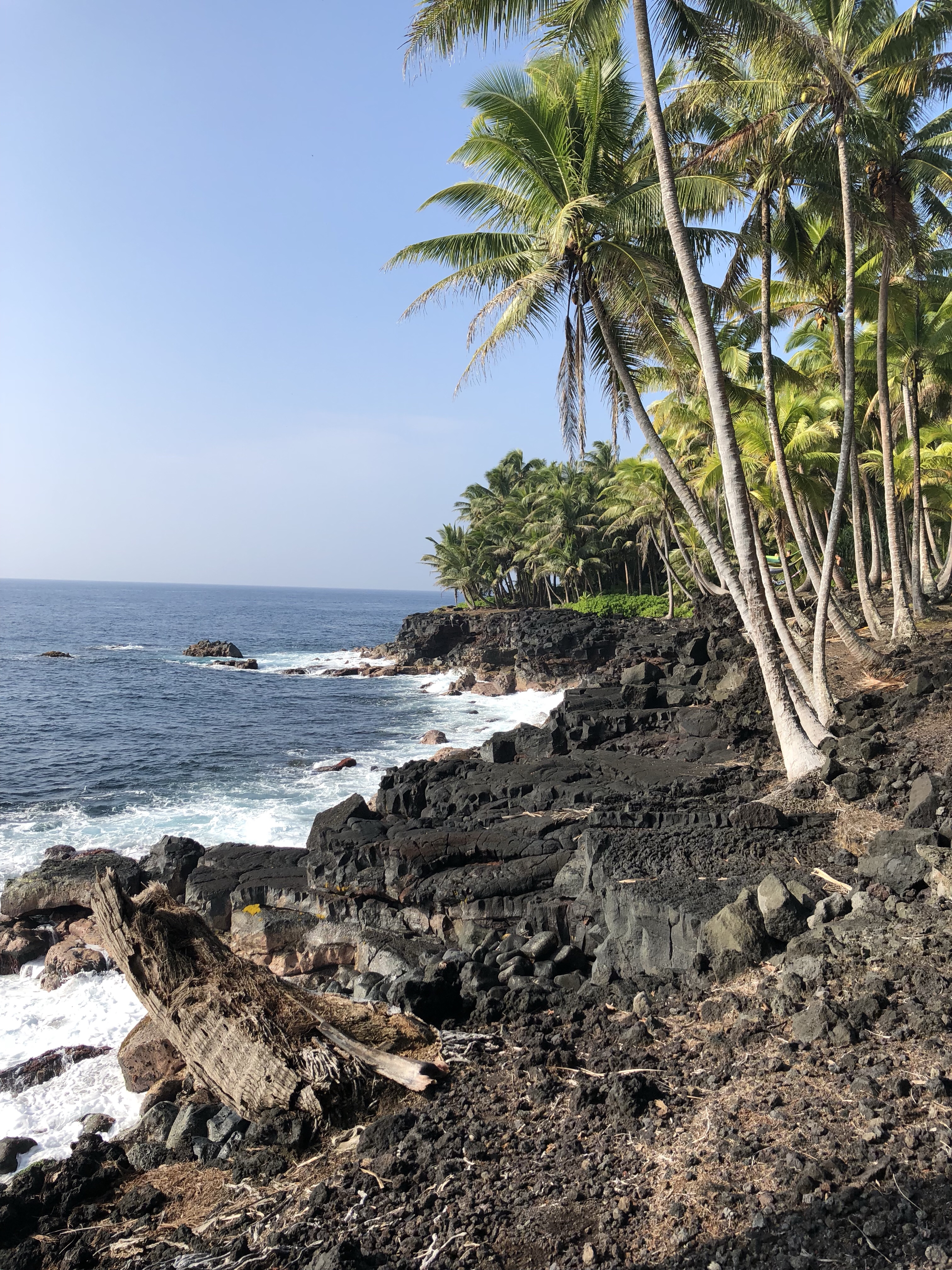
We drove to a beach on the Kona side. Despite having spent almost 4 days on the island, we hadn’t gone swimming yet. We fixed that at the beach. The beach we went to had these monster waves and was apparently a big place for boogie boarding. It was wild to see adult men getting destroyed on boogie boards by giant waves.

After we finished with the beach, we head back up the hills to Mountain Thunder Coffee Plantation to take their free coffee tour. The tour guide started by asking us if we knew where coffee came from (Ethiopia, I answered correctly), and how it was discovered (goats, I also answered correctly). It was a pretty interesting tour and I think I now know enough to quit my job and open a roastery.

After the tour, it was getting close to our flight. We weren’t super hungry, but the flight was 5 hours and we wouldn’t arrive til bedtime so we figured we should get one last meal. We opted to checkout Broke da Mouth Grindz – an excellent choice. We finished with a smoothie and then head to the airport. We dropped the car off without ever gassing-up which I would consider a win! Overall, a successful Big Island road trip!

Share:
Reading time: 2 min
Uncategorized

Big Island Day 2

January 15, 2018 by Elsbeth No Comments

After returning late from our evening lava hike, we decided to take it easy and make it a lazy morning. The Airbnb we stayed in was easily one of the best I have ever stayed in. The host offered us coffee and a half guava filled with granola. Just sitting there enjoying breakfast causes the morning to fly by.

We finally hit the road around 10 and opted to take the longer scenic route around the Puna coast. If I were to tell people to just see one part of the Big Island, I think Puna would be my first choice.

After finishing our casual drive around Puna, we head back into Volcanoes National Park. At the visitor center, we overheard someone saying the lava hike within the park was 12 hour round trip, so we felt happy that we had done it the night before. In the Park, we visited a lava tube, some steaming vents, and had a nice overlook of the crater from the museum. It was a pretty nice National Park to spend some time, but after we checked off the major attractions, we were feeling pretty hungry so we head into Hilo.

In Hilo we ate at Hawaiian style cafe. The food was pretty good. We ate a poke bowl and a mento bento. They both came in Hawaii size portion (huge).

After lunch, we needed to do a little exercise to burn off lunch, so we headed to Akaka Falls State Park. There was a paved 2 mile loop to view both falls in the park. This part of the island receives a crazy amount of rain and today was no different. We walked the loop in the rain. It was warm, though, so not too unpleasant.

After we finished the loop, we realized we had a lot of time before sunset with nothing left on the agenda, so we made the decision to detour to Mauna Kea, the tallest mountain on the island. We drove up on the Saddle Road through dense fog until all of a sudden the fog cleared – we were on top of the clouds!

They do not allow cars without 4wd above the visitor center (9,000 ft). So we spent some time reading the informational materials. There was a telescope set up with special filters to watch the sun. I looked through and saw a solar flare! After exhausting the visitor center, we climbed up a small local peak and watched the sunset from there. It was truly spectacular to watch the sunset with basically unobstructed views in all directions.

After sunset, we hopped back in the car and drove an hour and change to our hostel. When we arrived, we set our alarms to be ready for tomorrow’s sunrise hike ?

Share:
Reading time: 2 min
Uncategorized

Big Island Day 1

January 14, 2018 by Elsbeth No Comments

My Hawaiian vacation didn’t start off exactly as I was anticipating. At about 8 AM my phone and all phones around me starting blaring an emergency alert about an incoming ballistic missile. I absolutely went into panic mode. 38 minutes later a second message was sent out saying that it was a mistake. Stressful way to start the day.

We left around 9, about an hour late thanks to the ballistic missile, and headed to The Coffee Shack. The location is stunning, on a hillside overlooking the ocean. And they set out little pots of jelly so the geckos can eat breakfast with you.

After breakfast, we made our way down to Pu’uhonua Honaunau national Historic Park. This was once a sacred place for the ancient Hawaiians, and it was a beautiful place to visit! Today, it’s one of the most famous spots on the island for snorkeling. We didn’t have gear, but we were able to see two turtles from the shore.

Our next stop was the green-sand beach. We drove to the very southern point of the island, and the landscape changed dramatically as we did. At the parking lot, there is an option to walk to the beach (2.5 miles) or take the shuttle. In the interest of time, we took the shuttle.

The shuttle consists of standing in the bed of a beat up truck as it attempts to navigate the roads. An adventure itself! We got to the green sand beach, and it really wasn’t that green ? also, I had read that the green sand beach was not a swimming beach. It is. And a I wish I had worn a swimsuit.

On the shuttle back, we were treated to some whale performances. At one point two whale jumped out of the ocean in unison. It was pretty spectacular. We got back in the car and started making our way to Punaluu Black Sand Beach.

At the black sand beach we didn’t stay too long. We snapped some photos of the turtles that were laying out in the sand and then left to make it to our Airbnb before dark.

The last leg of the drive was through volcanoes National Park. Both the landscape and the weather changed dramatically here! For about 20 minutes we were driving through fog so dense you could only see 5 feet ahead. Finally the fog cleared to rain, but at least we could see.

We arrived at the Airbnb and I asked the host for dinner recommendations. She said her recommendation changes if we are doing the hike. “What hike?” I ask. “Oh, most people stay here to do the night hike to the lava”. She offered to share her dinner with us and then we head off.

At the end of the road, we parked our car, and rented some bikes and headlamps. We biked 2.5 miles down the road, stashed our bikes and head out onto the lava field. Supposedly it was a 1.5 mile walk to the lava flow. There was no path, you could see the bright red glow ahead but that was the only direction.

It took an hour, but eventually we were quite close. At this point the ground had gotten hot and you could see the glowing red in the cracks of the earth beneath your feet. We pushed right up to some active lava. Standing in the dark watching the red lava ooze through the earth, rebuilding as it went, was truly one of the most unforgettable moments of my life.

After we felt like we had our fill, we headed back to the bikes. If route finding was difficult on the way up, it was much more so on the way down. Only the occasional glimpse at a light in the distance, the rest was all guessing. We got back to our bikes, biked back to the car, drove back to the Airbnb and went to sleep. ?

Share:
Reading time: 3 min
Travels•Trip Report

Trip Report: San Ramon Waterfall

January 8, 2018 by Elsbeth 1 Comment

Distance: 6 Kilometers

Time: 2.5 hours

Before getting to Ometepe, I had wanted to climb Concepcion, the active volcano on the island. Unfortunately, the weather was less than cooperative.  December and January is generally considered dry season in Nicaragua, but the weather was rainy and overcast while I was on the island. Thick clouds are not great weather for climbing volcanoes. The clouds shroud the entire cone of the volcano with a dense blanket of fog.

I did not want to leave Ometepe without having done any hiking. The island is, after all, a nature-lovers paradise. So I opted instead for a hike that was less dependent on the weather: San Ramon Waterfall. The hike to the San Ramon Waterfall is a must-do on Ometepe. An added benefit, the trailhead is on the Maderas side of the island which was the side I was staying on. I hopped on a bike, rode the ~9 kilometers to the trailhead, paid the $3 entry fee (per person), and began my trek to the waterfall.

Kilometers 1 and 2

The road to the start of the San Ramon Waterfall trailhead on a sunny day with views of Lake Cocibolca

The first three kilometers are pretty much just a walk up a semi-paved hill. I did not know this before arriving at the trailhead, but for an additional fee, you can drive your motorcycle/scooter/quad up the first three kilometers of the trip.  It is not the nicest road in the world, but driving certainly makes it an easier trip. Even if we had ridden scooters instead of bicycles, I would not recommend biking up. The trail was a sustained climb, but did not justify motorized transport.

The weather was absolutely beautiful. After almost a full day of sporadic showers the day before, I was happy to see that it was going to be a sunny day. I started early enough in the day that the air was still cool despite being sunny. The green fields leading up the side of Maderas were absolutely stunning. Quickly, the fields turned into cloud-forest as I continued up the volcano. I welcomed the accompanying sun-showers.

Elsbeth staring at Volcan Maderas on the trail to the San Ramon Waterfall

Kilometer 3

It is obvious that there is an immediate change in the trail at the two-kilometer mark. This is where the fun part of the hike begins.  All vehicles are parked at kilometer two. Beyond that, the trail devolves into a rocky, mud path through the jungle.  There is a brief descent through a canyon with a welcome cool breeze. This part of the hike was beautiful, but not in a way that looks good in photos.

After some climbing through the jungle, I arrived at the first river crossing. I, mistakenly,  figured I must be close to the waterfall if I was crossing the river.  After a bit more climbing, I found myself in a canyon that felt straight out of Jurassic Park.  If a raptor had burst out around the corner, I would have felt just a normal amount of surprise.

The canyon on the trail

The next section of the hike was some minor scrambling up tiny waterfalls.  It was around this point in the hike that I realized the third kilometer was a “longer-than-average” kilometer.  Despite the official claim that the full trek to the waterfall is three kilometers, reports all over the internet state that it is closer to four. I am not sure I would say that, but I think the last kilometer was more like a mile.

At the San Ramon Waterfall

Vertical image of the San Ramon Waterfall

I did not find the hike particularly challenging. It was nonetheless a relief to finally arrive at the waterfall.  My skin was feeling sticky from climbing up in the humidity.  The thought of cooling off in the pool below the falls sounded quite refreshing.  Thanks to some foresight, I was able to strip down to the bikini under my clothes. The water was cold, even considering the sweat I had worked up.  I spent a few minutes cooling off in the water before retreating to a place nearby to dry-out in the sun.

Horizontal image of the San Ramon Waterfall showing people swimming in the pool below

Kilometers 4 Through 6

The return trip consists of going back down the same trail as the way up.  That is not to say that it is uneventful. There are beautiful views of Lake Cocibolca all the way down.  The sun was higher in the sky and the weather was much hotter. I did not have any sunscreen with me, so I can describe the trip down as light jogs between patches of shade. At the bottom, horses hanging out next to the lake welcomed me back.

I had not stopped for food on the way to the trailhead, so by the time I reached the bottom, I was pretty hungry.  There is a restaurant on the grounds of the trail, but I decided to eat at an inviting-looking place I had passed called Comedor Gloriana. Overall, I would say do not forgo the hike to the San Ramon Waterfall, even if you are staying on the Concepcion side of the island. Remember to bring a bathing suit, plenty of water, and if I were to do it again I would wear some type of water shoes.

Wild horse eating in front of Lake Cocibolca

Share:
Reading time: 4 min
Page 4 of 7« First...«3456»...Last »

Recent Comments

  • Dennis on The Kepler Track Trip Report
  • Stephanie Weeks on New Zealand Day 1
  • Dennis on The Complete Guide to the Isla de Ometepe
  • Travel With Trang on Big Island Day 3
  • Dennis on Big Island Day 3

Archives

  • July 2018
  • June 2018
  • February 2018
  • January 2018
  • December 2017
  • November 2017
  • October 2017

Categories

  • Best Day
  • Blog
  • Complete Guide
  • Diary
  • Lifestyle
  • Travels
  • Trip Report
  • Uncategorized

Recent Posts

Tongariro Alpine Crossing Trip Report

Tongariro Alpine Crossing Trip Report

July 17, 2018
The Kepler Track Trip Report

The Kepler Track Trip Report

June 24, 2018
The Routeburn Trip Report

The Routeburn Trip Report

June 15, 2018

New Zealand Day 8

February 21, 2018

New Zealand Day 6

Categories

  • Best Day
  • Blog
  • Complete Guide
  • Diary
  • Lifestyle
  • Travels
  • Trip Report
  • Uncategorized

Popular Posts

Trip Report: Trail of Ten Falls

Trip Report: Trail of Ten Falls

November 19, 2017
Trip Report: Cathedral Lake to Half Dome

Trip Report: Cathedral Lake to Half Dome

October 10, 2017

Big Island Day 3

January 16, 2018
Museum of Ice Cream vs Color Factory

Museum of Ice Cream vs Color Factory

December 10, 2017
Best Latte Art in San Francisco

Best Latte Art in San Francisco

November 4, 2017

Tags

Best Day coffee Laguna de Apoyo Nicaragua Oregon Portland San Francisco
Follow on Instagram

© 2017 copyright PREMIUMCODING // All rights reserved
Designed by Premiumcoding